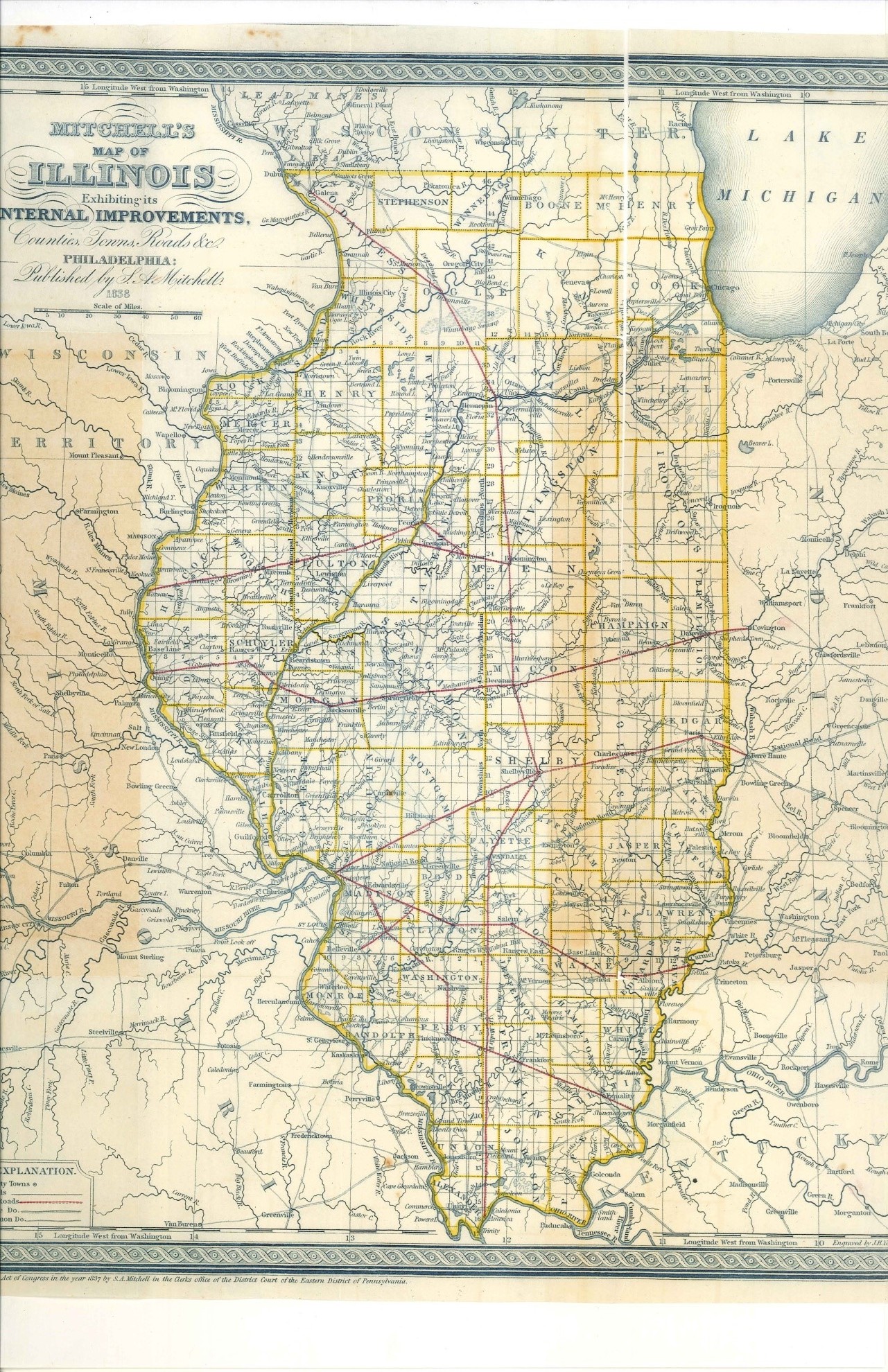
Nauvoo and the Illinois Internal Improvements Map of 1838
 Under the direction of Richard M. Young and several of the legal profession a memorial was drafted for Congress to assist them in solving the perils and problems wrought by nature. It was submitted late in 1835. It read:
To the Honorable the Senate and House of Representatives of the United States of America in Congress assembled:
The memorial of the citizens of Hancock County and its citizens in the State of Illinois respectfully represent that the navigation of the Mississippi River and the Des Moines Rapids is greatly disturbed by rocks, which render it not only difficult but very dangerous…Steamboats are often stuck on the rocks, their boilers have burst, several people’s lives have been lost and many others jeopardized…Above these Rapids, bordering on the Mississippi and its tributaries lies an extensive and fertile country, capable of supporting a dense population, much of it is yet beset by the general government and the value of which would be greatly enhanced by a free navigation. Add to this the lead in the country yet known. Immense quantities of lead annually pass over these rapids with a price levied upon it commensurate with the delays, difficulties and charges which have to be distributed… We therefore pray your honors to grant a sum of money to be applied in removing the obstruction in the Steamboat Channel on the lower or Des Moines Rapids and your memorialists as are duty bound shall be impressed with a deep sense of gratitude.
The first signatory was Richard M. Young, followed by Cyrus Walker, Charles Robinson, J.L. Walker, and O. H. Browning. Other prominent landowners signing included Wesley Williams, Walter Bagby, Hugh White, Onias Skinner, Adolphus Allen and several others.
In the adjoining state of Indiana, legislators were making serious plans for extensive internal improvements of their own as their General Assembly convened in December 1835.
Richard F. Barrett, Joseph Duncan, while Governor of the State, and Mark Aldrich inconspicuously associated themselves together in the ownership of their combined lots and formed a company under the name, “The Warsaw Land Company” on May 15, 1837.[i]
On February 19, 1839 the legislature established the Des Moines Rapids Railroad to be managed by eleven commissioners:[ii] These included: Mark Aldrich, Joseph Duncan, the former governor, Richard F. Barrett, Calvin A. Warren, Isaac Galland, Daniel S. Witter, David W. Matthews, John Montague, William D. Abernathy, Joel Catlin, and Isaac N. Morris.
Aldrich, Duncan, Barrett and Warren were associated with the Warsaw Land Company and Morris was the President of the Illinois and Michigan Canal. In addition, Mark Aldrich was associated with Joel Wright as a fellow Warsaw Peoria Railroad Commissioner and who also served as one of the seven commissioners of public works. The leadership of the Warsaw Land Company benefited from the inside information of the state’s priorities and issues involved in all the improvement projects and in the details of the Illinois and Michigan Canal construction.
This 1839 Act authorized capital stock for the Des Moines Rapids Company for $100,000. Its key provisions authorized construction of a railroad line:
“commencing on The Mississippi river at the head of the Des Moines rapids, at or near the town of Commerce, in Hancock county, and from thence, in the direction to Warsaw, to intersect the Peoria and Warsaw railroad at such point as shall be determined upon after a survey shall have been made of the route by and between the Board of Commissioners of Public Works and the said company; … and for the purpose of cutting, embankment, stone, and gravel, may take as much more land as may be necessary for the proper construction and security of said railroad:”
In the nearby town of Warsaw, in the debut issue of their local newspaper, Western World, May 13, 1840 a quaint article was written entitled “Our Town and County”. The piece was extolling the anticipated benefits the town citizens could experience.
Warsaw, the principal business town in the county, is situated on the fractional Section 9, in Township 4 North, Range 9 West, on a beautiful elevation, on the East bank of the Mississippi. It commands a fine view of the river for several miles in each direction, and has one of the best Steam Boat landings on the river. It is about 3 miles below the foot of the Des Moines rapids, is thriving rapidly, and is destined to attain a high rank among the towns of the west. The advantages of its situation are obvious, being opposite the mouth of the Des Moines river, and the point of termination of the Peoria and Warsaw Rail Road. A company of gentlemen, in February, 1839 obtained a charter from the Legislature of the State for a rail road around the Des Moines rapids, from Commerce to Warsaw, which is believed will be the most profitable Rail Road stock in the United States. The obstructions to Steam Boat navigation on the rapids are so great that the greatest part of the navigable season Steam Boats cannot ascend or descend with their cargoes with safety, and are under the necessity of lighting over the rapids in keel or flat boats drawn by team power. As the settlements on both sides of the river above this town increase, for a distance of some 5 or 600 miles above us, and as the resources of the upper country are brought into action, it is reasonable to suppose that trade and navigation on the Upper Mississippi will increase in the same proportion. If so, the importance of the rail road from Warsaw to Commerce, round the rapids, must be evident to every reflecting mind. It is expected that all the stock will be taken and the road commenced before the end of the present year, which when completed, will add much to the business and prosperity of the towns of Warsaw and Commerce…[iii]
Expectations were high that wealth was soon coming for the entire area from internal improvements. But what of the Mormons invading the area of the nearby town of Commerce?
The proposed Railroad and Turnpike roads were still showing in Brown’s 1844 map.
Both maps are in the possession of the author.
[i] Document on file at the Abraham Lincoln Presidential Library, MS “Joseph Duncan Document number SC 431”
[ii] Incorporation Laws of Illinois p. 75 in “AN ACT to incorporate the Des Moines Rapids Railroad Company” In force, Feb. 19, 1839
[iii] D. N. White Editor, Western World, Vol. 1 No. 1, May 13, 1840 (Warsaw)